Streamlined sampling process supports N3B’s environmental cleanup at LANL

Joint Press Release with N3B Los Alamos

MOUNTAIN VIEW, CA and LOS ALAMOS, N.M., 21 April 2022 —

A significant software improvement is driving enhanced decision-making on N3B Los Alamos’ environmental cleanup at Los Alamos National Laboratory (LANL).

Samples collected of soil, sediment, water and other parts of the environment potentially contaminated by historical LANL operations now receive faster and more comprehensive validation due to software tool improvements made by N3B and leading environmental software provider Locus Technologies.

The improved software functionality is part of a database containing all data associated with environmental cleanup at LANL. N3B implements the legacy portion of that cleanup on behalf of the U.S. Department of Energy’s Environmental Management Los Alamos Field Office. Legacy cleanup involves the remediation of contamination from Manhattan Project and Cold War era weapons development and government-sponsored nuclear research.

The software improvement ensures more thorough validation of results from third-party analytical laboratories that analyze collected samples for various contaminants, which may include metals, radionuclides, high explosives, and human-made chemicals used in industrial solvents, known as volatile organic compounds.

The types of contaminants potentially found in these samples, along with levels of contamination, guide N3B’s cleanup.

“Decisions on legacy environmental cleanup are based on the validity and quality of this analytical data, including the nature and extent of contamination, how much we clean up, and how well the interim remediation measure is working to mitigate migration of the hexavalent chromium groundwater plume,” said Sean Sandborgh, sample and data management director at N3B. “If you have lapses in the quality of analytical data, that could have negative effects on our program’s decision-making capacity.”

Once N3B personnel collect samples from potentially contaminated sites, they send them to a third-party laboratory for analysis. When N3B receives the results of those samples, they perform a validation process to demonstrate data is sufficient in quality and supports defensible decision-making.

“Validation consists of determining the data quality and the extent to which external analytical laboratories accurately and completely reported all sample and quality control results,” Sandborgh said.

The process can catch data quality issues that may result from incorrect calibration of equipment in a laboratory or issues inherent in the samples, such as improper preservation or temperature control, that mask detection of contaminants.

With the improved functionality, more of the validation process is automated, instead of manually conducted, which means a lower likelihood of errors.

Another crucial improvement is the ability to evaluate sample results containing radioactive material at lower activity concentrations, which provides quick information on the potential for low levels of radionuclide activity.

The improved functionality is also being used by LANL’s management and operating contractor, Triad, and will soon be used by the New Mexico Environment Department Oversight Bureau.

The software improvement saved N3B 265 hours of labor and more than $25,000 in taxpayer dollars since its launch nearly one year ago.

“As we’ve done for the past 25 years, Locus is committed to continually improving our solutions for the often costly and complex data review process,” said Locus Technologies President Wes Hawthorne. “We are proud to enable a data-forward approach with a focus on accuracy that results in confident and correct decisions.”

“The quality and defensibility of environmental data generated from sampling activities is a key component of an effective remediation process,” said Sandborgh. “When the automated data review is used in conjunction with manual examination of sample data packages, we meet and exceed our data quality requirements.”


ABOUT N3B Los Alamos
N3B manages the 10-year, $1.4 billion Los Alamos Legacy Cleanup Contract for the U.S. Department of Energy Environmental Management’s Los Alamos Field Office. N3B is responsible for cleaning up contamination that resulted from LANL operations before 1999. N3B personnel also package and ship radioactive and hazardous waste off-site for permanent disposal.

Environmental Reports Tailored to Your Needs

Companies across a wide array of industries utilize Locus Environmental Information Management (EIM) software. Some examples include petroleum companies with over 6,000 sites, fracking companies with 3,000 plus sites, leading chemical corporations, engineering firms, private and public water utilities, DOE facilities, Native American tribes, aerospace companies, representatives of the electronics industry, and more. There is not a single report that these companies share in common, and as such, our approach to reporting recognizes our customers’ diversity.

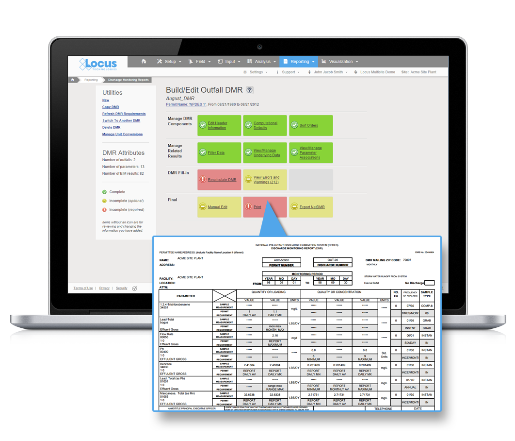
DMR builder and report in EIM

Instead of focusing on canned reports, we provide users with the tools to build their own custom reports—enabling them to design exactly what they need, either independently or along with our stellar support team. To make the transition to Locus EIM as easy as possible, we ask our customers about their top reporting priorities. Then, we build reports to match their specifications during the implementation process to be up and running from day one. Not only does this facilitate the transition to our system, but it also gives our customers examples of how to build their custom reports.


Grid Reports

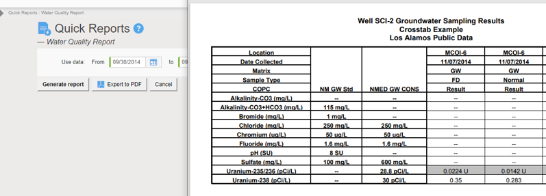
Before we delve into EIM’s formatted reports module, keep in mind that many of our customers’ reporting needs are met by EIM’s grids. For example, here is a sample grid populated with analytical results that match some previously chosen selection criteria:

Locus EIM Grids

One-click and this becomes an Excel spreadsheet (or any of a range of file formats) to which you can add a title, edit the column headers as needed, and if required, engage in further formatting.

Locus EIM Grid Report


Formatted Reports

Let’s now move on to EIM’s formatted reports module. Templates provide EIM with instructions concerning report layouts, content, and formatting. They do not address which records stored in EIM are to appear in the report. Template creation requires more in-depth knowledge of EIM and needs to be done only once for any given report format. Running a report is a more straightforward task. The same report can be re-run any number of times using different selection criteria. For example, it is not uncommon for a customer to print a monthly, quarterly, or even annual report using the same template. All that changes from one reporting period to the next is the selected sampling or measurement date range. Upon saving your entries, the report is ready to be used by others, unless designated as private.

To run a formatted report in EIM, all you need to know is what filters should be chosen to display only the relevant set of data. Aside from date ranges, what are examples of selection criteria available to you when executing a formatted report? For example, you can select individual locations or named location groups; individual or named groups of parameters; one or more sample types, sample purposes, samples, sampling programs, sampling events, or sample delivery groups; a range of sample depths; only filtered or unfiltered samples; only leached or not leached analyses; one or more EDDs; and one or more work order numbers to name a few.

Locus Formatted Reports


Expert SQL Query Reports

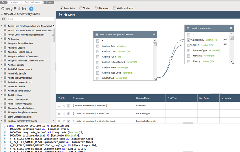
The expert query tool allows the user to retrieve records from many EIM data tables with a flexible interface, where join and column definitions are customized. The expert query output can be scheduled as an attachment to an email or run as needed, private or public, or saved on the dashboard for ultimate access by all user levels.

The EIM Expert Query Tool (EQT) lets users create their database queries using a drag-and-drop table interface. Users can also directly write T-SQL language requests to pull data from EIM. This powerful tool empowers the super users to take full advantage of the data managed in EIM and creates “custom reports” without the need for a developer.

Locus Expert SQL Query


Additional Reports

Additional reports include DMR reports (formatted and NetDMR); Self-monitoring; Regulatory formatted exports (various EPA regions); Consumer Confidence Reports; Data Validation (in association with the Data Validation Module); Coliform reports (Water configuration); custom DMR reports and custom MSGP reports; and a wide range of metric reports for usage statistics, records, sites, and management reports including holding table metrics, SDG turnaround times, reporting tool metrics, and LocusDocs metrics.


Contact us for a demo of Locus EIM

    Name

    Company Email

    Phone

    Tell us about your company's needs

    Locus is committed to preserving your privacy.

    How to extend your EHS software with integrated systems

    Integration with other systems, whether on-premises or in the cloud, has become a key wishlist item for many EHS software buyers. It allows you to take advantage of other tools used by your organization (or available from third parties) to simplify processes, access information, and enhance communication, both internally and externally.

    WM Symposia 2018 provided an excellent showcase for Locus GIS+ in LANL’s Intellus website

    At the annual WM Symposia, representatives from many different DOE sites and contractors gather once a year and discuss cross-cutting technologies and approaches for managing the legacy waste from the DOE complex.  This year, Locus’ customer Los Alamos National Laboratory (LANL) was the featured laboratory.  During their presentation, they discussed Locus GIS+, which powers Intellus, their public-facing environmental monitoring database website.

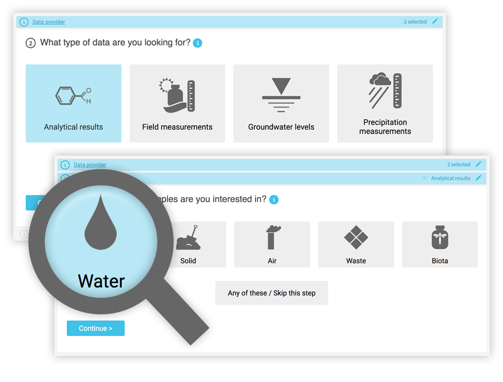
    If you haven’t been to LANL’s Intellus website recently, you are in for a surprise!  It was recently updated to better support casual users, and it features some of the best new tools Locus has to offer.  Locus reimagined the basic query engine and created a new “Quick search” to streamline data retrieval for casual users.  The guided “Quick search” simplifies data queries by stepping you through the filter selections for data sources, locations, dates, and parameters, providing context support at each step along the way.

    Intellus - quick searchWhile a knowledgeable environmental scientist may be able to easily navigate a highly technical system, that same operation is bound to be far more difficult for a layperson interested in what chemicals are in their water.  Constructing the right query is not as simple as looking for a chemical in water—it really matters what type of water you want to look within.  On the Intellus website (showing the environmental data from the LANL site), there are 16 different types of water (not including “water levels”).  Using the latest web technologies and our domain expertise, Locus created a much easier way to get to the data of interest.
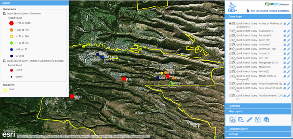
    Just querying data is not necessarily the most intuitive activity to gain insights.  Locus integrated our new GIS+ visualization engine to allow users to instantly see all the data they just queried in detailed, context-rich maps.

    Intellus GIS+ Map

    Intellus GIS+ map showing “Quick search” query results for chromium levels in the LANL area

    Instead of a dense data grid, GIS+ gives users an instant visual representation of the issue, enabling them to quickly spot the source of the chemicals and review the data in the context of the environmental locations and site activities.  Most importantly for Intellus users, this type of detailed map requires no GIS expertise and is automatically created based on your query.  This directly supports Intellus’ mission to provide transparency into LANL’s environmental monitoring and sampling activities.

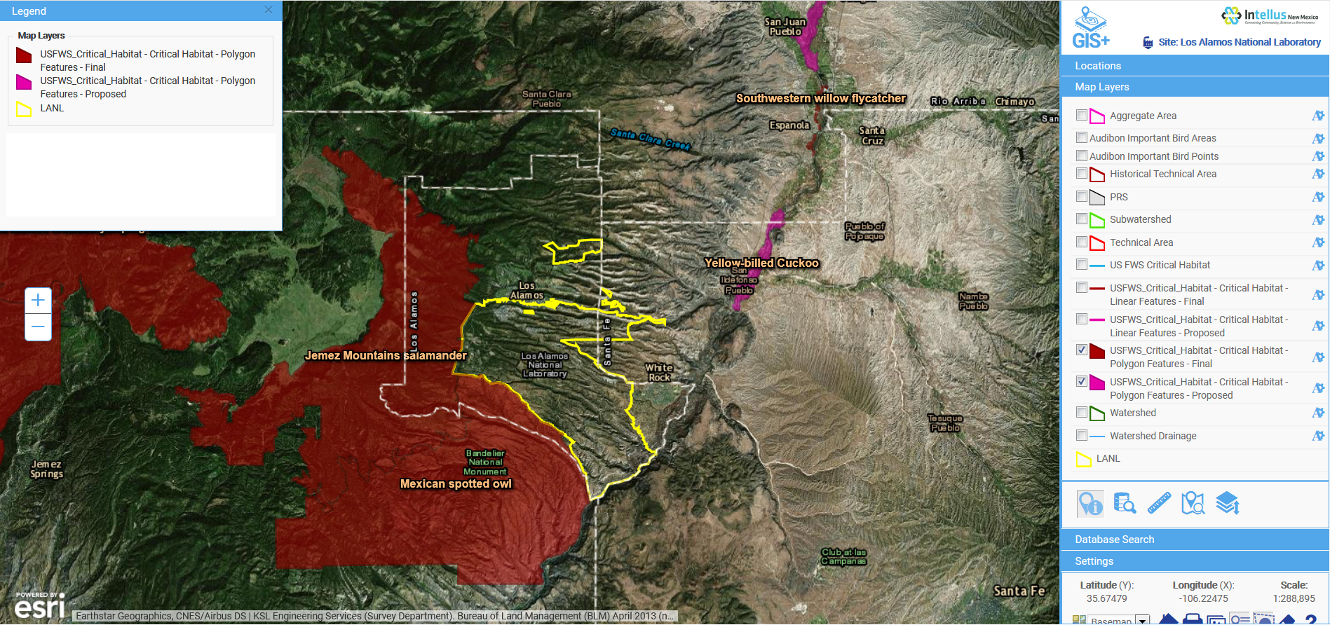
    GIS+ also allows users (albeit with a bit more experience in GIS mapping) to integrate maps from a wide range of online sources to provide even more insight to the available data.  In the example below, we overlaid the publicly-available US Fish and Wildlife critical habitat maps with data from the LANL site to show the relationship of the site to critical habitats.  This type of sophisticated analysis is the future of online GIS.  Locus takes full advantage of these opportunities to visualize and integrate data from varying sources with our GIS+ tools, made simple for users and integrated with ArcGIS Online by Esri.

    Intellus GIS+ Map

    Intellus GIS+ map showing imported layers of US Fish and Wildlife critical habitats in relation to LANL environmental sampling data

    WM 2018 - Sean and Nita

    Overall, Locus is very proud of our cross-cutting environmental information management tools.  We were one of many WM18 attendees enjoying LANL’s presentation and getting even more ideas from the audience on the next steps for better environmental visualization.

    [sc_button link=”https://www.locustec.com/wp-content/uploads/2018/03/WM-18-PPT.pdf” text=”View a copy of the presentation” link_target=”_blank” color=”ffffff” background_color=”52a6ea”]

    Data mining gains more cachet in construction sector

    Locus is mentioned in ENR’s article about data mining, discussing how Locus software helps our long-time customer, Los Alamos National Laboratory, manage their environmental compliance and monitoring.

    Environmental and Sustainability Software: How one company’s cloud environmental and sustainability software is changing how firms and government manage environmental information.

    How one company’s cloud environmental and sustainability software is changing how firms and government manage environmental information.

    Locus’ Intellus Promotes Big Data Transparency: More Than 14 Million Environmental Sampling Records from National Laboratory Are Now Available Online

    Previously contained in a dozen independent databases, the integrated records of Los Alamos National Laboratory (LANL) — are now stored in one location, the publicly-accessible website Intellus.

    Through the Locus EIM platform public facing website, Intellus, the general public can now access remediation and environmental data records associated with the Office of Environmental Management’s (EM’s) legacy nuclear cleanup program.

    Containing more than 14 million records, Locus’ Intellus has consolidated Los Alamos National Laboratory’s (LANL’s) information that was previously handled in multiple independent databases. The centralized, cloud-based solution directly attributed to an estimated $15 million in cost savings for LANL through 2015.

    The public facing site also ensures users have real-time access to the most recent data. The same data that scientists and analysts use to base important environmental stewardship decisions off of. Through tools and capabilities such as automated electronic data validation, interactive maps, and the ability to include data from other third-party providers and environmental programs, Intellus provides the ultimate platform to view LANL’s environmental data without compromising the core EIM system that LANL scientists use on a daily basis.

    Locus has always advocated for the power of data transparency via the cloud. When you apply the most extensive security protocols to a cloud-based system, it can be a winning combination for data management and public trust.

    Versar, Inc. Selects Locus’ EIM as its Standard Environmental Data Management System

    Locus EIM to assist Versar by supporting ERPIMS exports for U.S. Air Force remediation projects

    SAN FRANCISCO, Calif., 7 January 2014 —Versar, Inc. (NYSE MKT:VSR) has selected Locus Technologies’ (Locus’) Environmental Information Management (EIM) software to be its preferred environmental data management system for the firm’s Performance Based Remediation (PBR) program for the U.S. Air Force (USAF).

    Versar will take advantage of EIM’s ability to support analytical data compatible with Environmental Resources Program Information Management System (ERPIMS), the electronic system that the Air Force uses for validation and management of data collected from environmental projects at its bases. In addition, Versar will utilize the ERPIMS regulatory export feature and the EIM data validation module.

    Versar is currently providing PBR services to the USAF under the 2009 Worldwide Environmental Restoration and Construction (WERC 09) contract through September 2020. The Versar Program, as both Prime contractor and Team subcontractor, presently includes nearly 200 contaminated sites at 15 Air Force bases in 10 different states across the U.S. The total value of the work (if all options are awarded) is approximately $110M; Versar is the Prime contractor with direct responsibility for 128 sites valued at $93M under three separate Task Orders (TOs) and is a Team subcontractor on a fourth TO.

    “We are very proud Versar has determined that EIM has the robust and versatile functionality to meet the company’s data management requirements for its USAF PBR Program,” said Neno Duplan, President & CEO of Locus. “We are constantly striving to incorporate specific features into our software, such as the ERPIMS compatibility, that will make a big difference for our customers.”

    ABOUT VERSAR, INC.
    Versar, headquartered in Springfield, VA, is a publicly traded global project management company providing sustainable, value-oriented solutions to government and commercial clients in engineering, construction management, environmental services, and munitions response market areas. For more information, visit www.versar.com.

    Los Alamos National Laboratory Extends Contract with Locus Technologies for Four More Years

    Locus to continue managing environmental data and information for the nation’s largest laboratory

    SAN FRANCISCO, California and LOS ALAMOS, New Mexico, October 28, 2013 — Locus Technologies (Locus), the industry leader in Web-based environmental software, announced today that Los Alamos National Laboratory (LANL) has chosen to extend its contract with Locus for four more years.

    LANL is a United States Department of Energy (DOE) national laboratory, managed and operated by Los Alamos National Security (LANS), located in Los Alamos, N.M. LANL conducts multidisciplinary research in national security, outer space, renewable energy, medicine, nanotechnology, and supercomputing. LANL is one of three laboratories in the United States at which the government conducts classified work to care for the nation’s nuclear weapons stockpile.

    Modifications that accompany the extended contract include additional functionality for air data management and reporting that involves better flexibility for increased data transparency. LANL also will put more focus on field and mobile devices, and significant enhancements will be made to Intellus New Mexico, the public-facing website that Locus created for LANL’s data.

    The original contract between LANL and Locus began in 2011, with the option of extending the contract for four additional years. LANL will continue to use Locus’ Environmental Information Management software (EIM) to address legacy site contamination and to take a better aggregate view of its operations for environmental stewardship.

    “We are very proud that LANL trusts our EIM software to continue assisting it with its environmental data management requirements,” said Neno Duplan, President and CEO of Locus. “We look forward to continuing to work with the team of talented professionals at LANL, and also continuing to assist DOE sites with their environmental data management challenges.”

    “High-quality data is a crucial component in environmental stewardship and our commitment to transparency with the public,” said Chris Echohawk, office leader of the Laboratory’s Operations Improvement Office.


    ABOUT LOS ALAMOS NATIONAL LABORATORY
    Los Alamos National Laboratory, a multidisciplinary research institution engaged in strategic science on behalf of national security, is operated by Los Alamos National Security, LLC, a team composed of Bechtel National, the University of California, the Babcock & Wilcox Company, and URS for the Department of Energy’s National Nuclear Security Administration.

    Los Alamos enhances national security by ensuring the safety and reliability of the U.S. nuclear stockpile, developing technologies to reduce threats from weapons of mass destruction, and solving problems related to energy, environment, infrastructure, health, and global security concerns.

    LANL news media contact: Fred deSousa, (505) 665-3430, fdesousa@lanl.gov

    Locus Introduces Software Functionality to Support ERPIMS Imports and Exports

    Companies can now use Locus’ EIM software to comply with the U.S. Air Force standard ERPIMS system

    SAN FRANCISCO, Calif., 16 September 2013 — Locus Technologies (Locus), the leader in cloud-based environmental compliance and information management software, has expanded its award-winning Environmental Information Management (EIM) software to support ERPIMS imports and exports.

    The Environmental Resources Program Information Management System (ERPIMS) is the system that the U.S. Air Force uses for validation and management of data from all environmental projects at its bases. This data can be complex, containing analytical chemistry samples, tests, and results, as well as monitoring well specifications, descriptions of sites, and hydrogeological information. It can also be a challenge for organizations working on relevant Air Force projects to correctly abide by ERPIMS formatting. In order to support these organizations, Locus has added ERPIMS laboratory imports and critical regulatory exports to its EIM software.

    “Locus’ EIM has been managing detailed analytical information since 1999, and today manages environmental data for some of the world’s largest companies,” said Neno Duplan, President and CEO of Locus. “Incorporating ERPIMS compatibility within EIM is just another example of how we are constantly striving to make processes simpler for our current and future customers.”

    EIM was the first subscription-based application to organize, manage, and report sampling, analytical and subsurface data in the Cloud. The ERPIMS import and export functionality is the newest component in EIM, and is available for use immediately.