Pioneering EHS Compliance and Sustainability: Locus Mobile Apps Revolutionize the Industry
Locus Technologies is excited to share a momentous milestone with you, we are celebrating 25 years of our mobile applications!
Locus Technologies is excited to share a momentous milestone with you, we are celebrating 25 years of our mobile applications!
Locus offers practical tools to monitor water usage, anticipate demand fluctuations, and ensure compliance with environmental regulations.
SAN FRANCISCO, Calif., Jan. 16, 2024 — Locus Technologies, (Locus), the pioneer in water, Environmental, Health, and Safety (EHS) compliance and Environmental, Social, and Governance (ESG) software solutions, announces expansion of its water management SaaS platform to include management of produced water within the oil and gas industry. This cutting-edge solution, seamlessly integrated with Locus’ suite of applications, underscores the company’s unwavering commitment to driving sustainable practices while optimizing operational efficiency.
Locus has engineered a comprehensive application designed specifically for the efficient and sustainable management of produced water. This latest addition to Locus’s suite of water solutions aims to address the complex demands of the oil and gas industry while ensuring compliance, conservation, and operational excellence.
The new application is seamlessly interoperable with other Locus solutions catering to the oil and gas sector, such as ESG, air emissions, waste management, and water quality management. Locus software empowers organizations to make informed decisions, mitigate risks, and enhance overall efficiency across their operations by streamlining data integration and providing actionable insights.
Locus’ CEO, Neno Duplan, emphasized the company’s dedication to delivering comprehensive water management solutions while driving advancements in technology for the beneficial reuse of water beyond the realms of the oil and gas, and energy industries. “We remain focused on delivering comprehensive water management solutions to our customers while advancing technologies for the beneficial reuse of water inside and outside of the oil and gas industry, which holds the promise of further improving the sustainability of our customer’s operations,” stated Duplan.
With a proven track record in providing leading-edge EHS and ESG software solutions, Locus continues to spearhead advancements in compliance, sustainability, and corporate responsibility across diverse industries and geographies.
About Locus Technologies
Locus Technologies, the global environmental, social, governance (ESG), Sustainability, and EHS Compliance software leader, empowers companies of every size and industry to be credible with ESG reporting. From 1997 Locus Technologies pioneered enterprise software-as-a-service (SaaS) for EHS Compliance, water management, and ESG credible reporting. Locus apps and software solutions improve business performance by strengthening risk management and EHS for organizations across industries and government agencies. Organizations ranging from medium-sized businesses to Fortune 500 enterprises, such as Chevron, Sempra, Corteva, DuPont, Chemours, San Jose Water Company, The Port Authority of New York and New Jersey, Port of Seattle, Onto Innovations, and Los Alamos National Laboratory, have selected Locus.
Locus Technologies’ headquarters is in Mountain View, California.
For further information regarding Locus Technologies and its commitment to excellence in SaaS solutions, please visit www.locustec.com or email info@locustec.com.
Business intelligence (BI) is a critical component of any organization. BI lets you analyze data on your processes and products, so you have the information needed to make decisions and take actions to improve your business’s performance. BI applications have been available for several years, with offerings from many companies including Microsoft, Oracle, SAS, Qlik, and Tableau.
Initially, BI was focused on just a few areas such as finance, logistics, and sales. As BI effectiveness evolves you need information covering all aspects of your business. One key information set is spatial information, which is usually managed in a geographic information system (GIS). GIS applications have been available since 1965 but only became widely commercially available in the 1980s when ESRI released its first GIS applications. Since then, GIS has spread from the desktop to mobile devices and the cloud.
Often, an organization’s spatial data is separate from other data, kept in its own department or application. For example, your organization might have a GIS department that manages geographic information for your facilities. However, spatial data might also be in other departments such as sales (locations of clients); physical plant (buildings, infrastructure, assets); logistics (sales or delivery routes), or even human resources (safety incident locations). It can be challenging to bring together these disparate spatial data sources and integrate them with non-spatial data stored in spreadsheets, databases, files, and other data warehouses.
Several recent business trends, however, have made it much easier to bring together both spatial and non-spatial information to support GeoBI or Geographic Business Intelligence. First, the rise and ubiquity of the internet ‘cloud’ has made it possible for an organization to put all their data into the cloud. Your business staff can now access all your data, regardless of the physical location of the data or your staff. Second, GIS has evolved from its earlier days when it was a way to automate traditional cartography. Now, GIS supports advanced spatial analysis and visualization techniques, including buffering, contouring, interpolation, network analysis, and 3D mapping. And third, new applications and methods have broken the barriers between spatial and non-spatial data. GeoBI software applications can manage both types of data, letting you combine all your data for analysis and visualization. Applications that don’t explicitly support both types can be connected through the use of application programming interfaces (APIs) for seamless transfer of data.
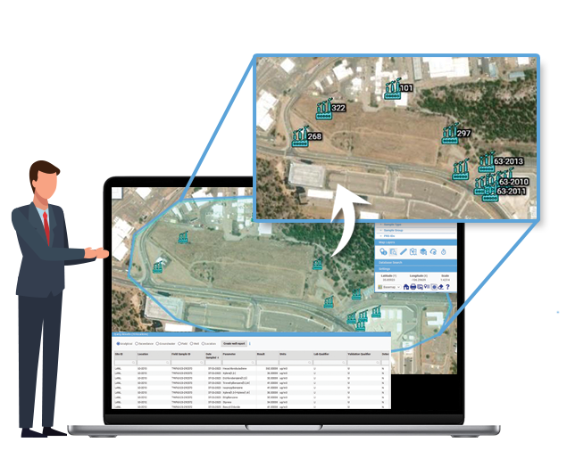
Locus Technologies has been a leader in bringing GeoBI to environmental data management. Locus’ software supports non-spatial data analysis via reporting, charting, and expert query functionality. The Locus GIS+ add-on lets you add spatial data to your analysis with the GIS+ functions for spatial query, data classification, time series analysis, buffering, and contouring. Let’s look at some examples.

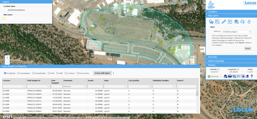
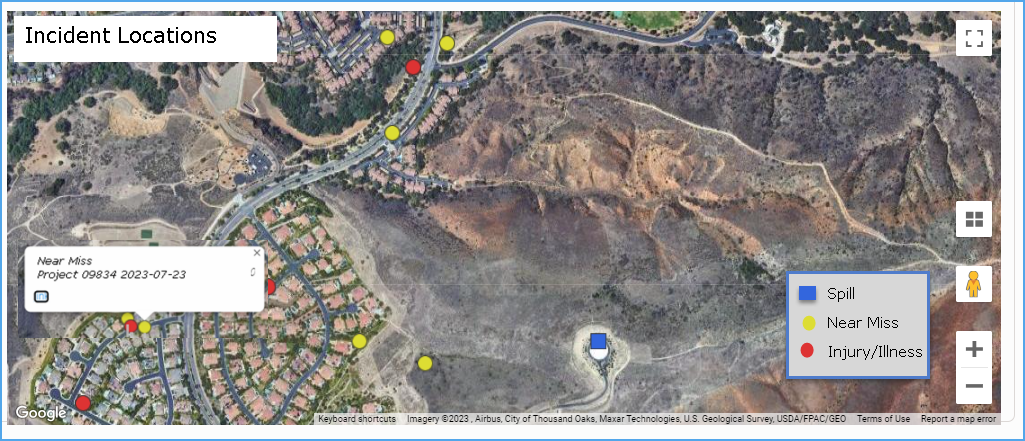
The above examples show how GeoBI can bring all your data together for use in analysis and decision-making, leading to a more complete picture of your facilities and processes. Furthermore, by having one suite of applications for your GeoBI needs, your organization can be more efficient. If spatial and non-spatial data are in separate silos, accessible only by different staff, it is difficult for one person to perform a complete analysis. Files, maps, spreadsheets, and other data objects must be shuffled between different persons and applications. With your data in Locus software, a full GeoBI analysis can be performed by one person, leading to productivity gains and cost reductions.
In the future, advances in artificial intelligence (AI) could lead to GeoAI, which would combine GeoBI with powerful features such as predictive analytics, pattern mining, and anomaly detection. Stay tuned for a future blog post on these exciting possibilities!
Acknowledgments: All the data used in the examples was obtained from the publicly available chemical datasets online at Intellus New Mexico.
I am constantly reminded by the number of calls we receive, that no matter how robust a SCADA and HMI system is, there is always a requirement for in-field O&M verifications and documentation. It’s almost universal and spans a myriad of industries, large and small, the need to monitor and record thousands of periodic (daily/per shift/weekly, etc.) routine readings/recordings at a prescribed frequency often recorded on pen to paper field forms. The same processes sometimes use “template” spreadsheets for data collection that are then emailed/placed on shared file servers or otherwise sent to some central location for review and post-processing. These processes are antiquated and subject to data quality and record-keeping challenges.
It’s time for an upgrade!
Electronic forms are great for collecting data and almost every business entity has built such forms in spreadsheets, word processing, or simple databases to collect the information. In addition, there is a software category of form builders, and they can certainly build forms. The question becomes is it a good fit to solve your business process issues?
Most customers have more sophisticated needs than simply collecting information on one or more custom forms – they want to do something with all the information collected far beyond what simple form builder tools can provide. Even customers with sophisticated spreadsheet forms, can’t manage them as they multiply exponentially or their Excel gurus retire.
Locus Platform is a configurable platform with standard applications that are easy to configure to customers’ unique requirements. One of its many strengths is its powerful form builder capable of creating simple or complex forms with simple or sophisticated logic. So, for customers looking to move from paper and spreadsheet templates, it’s an excellent option to consider, especially if you require more than a simple “fill in the blank” form for transmittal using mobile devices. Best of all, the data are securely stored in a database structure for reporting and alternative business uses and analyses, compared to the almost impossible management of hundreds of spreadsheets or paper forms.
If you still rely on paper forms and template spreadsheets and are ready to streamline your process and enhance the value of your data, give us a call and we can show you a range of options that will retire the paper forms for good!
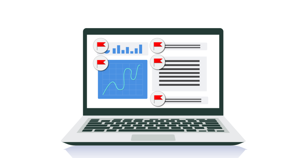
For 26 years, Locus Technologies has been helping organizations that serve millions of people a day. Throughout that time, our team of experts have noticed some common red flag with the alternative solutions that are available on the market. The alternatives can be more problematic that helpful, creating data congestion and slowing down your workflow. Your organization deserves a solution that alleviates the burdens of data entry, regulatory compliance, voluntary reporting, and more. Here are the top five signs that your organization is using outdated water software:
To ensure the highest level of data quality, you should not be risking human error at multiple levels. Enter your data once, and have it audit-ready, set to go on regulatory and voluntary reports, which are created directly from Locus Software.
Support doesn’t end after implementation. What we often hear from our customers when they switch from other providers is that they are delighted with the level of support that Locus brings with our software. Locus is proud to have the expertise and experience to back our software, and if there is anything you need, you can be sure that Locus support can get it done smoothly.
You need reliability. Your software should be available to you on-demand. Locus is proud to be the only environmental software developer to publicly share our uptime, which is over 99.9%. If you are experiencing downtimes at inconvenient times or for long periods, you should switch.
Field collection is key for most organizations managing water quality data. You should be able to enter that data into your system once, and from anywhere, reducing errors and extra time doing the same work twice (or more!). Also, being able to access historical data at your fingertips can help you solve problems on the fly.
Sure, you may have all your data collected, but what are you doing with it? If your software is not giving you meaningful findings from analyzing your data, then you are always going to be playing catch-up. Having the tools to help your organization look forward is essential in selecting water data management software.
MOUNTAIN VIEW, Calif., 2 March 2023 — Locus Technologies, the leading EHS Compliance and ESG software provider, received their 17th consecutive award from Environmental Business Journal (EBJ) for growth and innovation in the field of Information Technology in the environmental software with particular focus on EHS, compliance, sustainability, and ESG.
Locus continues to expand its ESG SaaS solution, including built-in business intelligence tools for interactive, actionable insights into unified EHS compliance and ESG data, forecasting tools predicting future ESG reporting, APIs for utility data sources, and interfaces with third-party systems that house ESG data. Locus’s ESG solutions focus on “enter once, report to many.” enabling companies the efficiency of reporting to multiple organizations and numerous standards from a single dataset. Essential built-in reporting includes state or federal regulations and ESG based on standards, including CDP, GRI, SASB, TCFD, and many others.
“Locus’s pioneering work in integrated ESG reporting and EHS compliance software is paying off. As one of the early SaaS leaders in net-zero digital solutions for ESG reporting, Locus continues to provide value to companies that want to be credible with their carbon reporting and sustainability software.” said Grant Ferrier, president of Environmental Business International Inc. (EBI), publisher of Environmental Business Journal.
“With energy transition, climate resilience, and new federal programs driving business, as well as traditional environmental market drivers in infrastructure, air quality, remediation, water and wastewater it is understandable that companies that offer integrates SaaS platform like Locus has advantage.” added Ferrier.
“As Locus continues to expand our EHS and ESG software we would like to thank EBJ for recognizing Locus again for a 17th consecutive year and for noting the new functionality and growing customer base we achieved in 2022. Locus will continue this trajectory into 2023 with new tools designed to simplify EHS and ESG management in our award-winning Locus software, which offers a single system of record and truth for our customers. Locus SaaS platform enables our customers to manage their carbon transactions and inventory with the same rigor, confidence, and transparency as their financial ones.” said Neno Duplan, the Founder and CEO of Locus Technologies.
MOUNTAIN VIEW, Calif., 14 February 2023 — Locus Technologies, the leading EHS Compliance, and ESG software provider, today announced that San Jose Water (SJW), an investor-owned public utility providing water service to a population of approximately one million people in the Santa Clara Valley, has expanded Locus’ environmental information management software to use Locus GIS+ for advanced GIS analysis.
SJW has been using Locus SaaS and mobile app since 2014 to manage its field data collection, water quality compliance, and regulatory reporting. SJW also uses Locus to track sewer discharges and well blow-offs.
“Our responsibility is to ensure our customers receive the highest quality drinking water from their taps. We monitor the quality and cleanliness of our water in terms of state and federal regulatory requirements. In 2021, our highly experienced staff collected more than 1,000 regulatory and non-regulatory samples from our distribution system and treatment plant, generating over 23,000 data points. To manage this data effectively, we used Locus’ cloud-based software. GIS mapping capabilities are essential for our environmental data analysis. Locus GIS+ will allow quick data visualization and is a quantum leap forward with advanced analysis tools that use Esri’s Smart Mapping technology,” said Suzanne DeLorenzo, the Director of Water Quality at San Jose Water.
“Locus’s mission is to help organizations, such as San Jose Water, to achieve their business goals by providing them the software tools to manage key data associated with water quality and compliance reporting,” said Neno Duplan, CEO of Locus. “With GIS+, SJW will have all the tools they need to perform a wide range of geospatial data analysis across their distribution system. Our water quality management cloud-based software, coupled with GIS+ and Locus Mobile for field data collection, provides our customers with a highly scalable and feature-rich application that gives water utilities strong analytical power and advanced GIS capabilities.”
Locus GIS+ is powered by Esri’s ArcGIS platform and offers various advanced features— including enhanced cartography, comprehensive spatial data analysis, and the ability to use the customer’s map data through integration with ArcGIS Online and Portal for ArcGIS.
ABOUT SAN JOSE WATER
Founded in 1866, San Jose Water is an investor-owned public utility and is one of the largest and most technically sophisticated urban water systems in the United States. Serving over one million people in the greater San Jose metropolitan area, San Jose Water also provides services to other utilities, including operations and maintenance, billing, and backflow testing. San Jose Water is owned by SJW Group, a publicly-traded company listed on the New York Stock Exchange under the symbol SJW. SJW Group also owns Connecticut Water Company in Connecticut; Maine Water Company in Maine; and SJWTX, Inc. (dba Canyon Lake Water Service Company) in Texas. To learn more about San Jose Water, visit www.sjwater.com.