Compliance Minute – Capturing Scope 3 Emissions for your ESG Report
When looking for a GHG reporting program, there is one element that is typically overlooked. This short video gives us more insight.
When looking for a GHG reporting program, there is one element that is typically overlooked. This short video gives us more insight.
When looking for a GHG reporting program, there is one element that is typically overlooked. This short video gives us more insight.
Business intelligence (BI) is a critical component of any organization. BI lets you analyze data on your processes and products, so you have the information needed to make decisions and take actions to improve your business’s performance. BI applications have been available for several years, with offerings from many companies including Microsoft, Oracle, SAS, Qlik, and Tableau.
Initially, BI was focused on just a few areas such as finance, logistics, and sales. As BI effectiveness evolves you need information covering all aspects of your business. One key information set is spatial information, which is usually managed in a geographic information system (GIS). GIS applications have been available since 1965 but only became widely commercially available in the 1980s when ESRI released its first GIS applications. Since then, GIS has spread from the desktop to mobile devices and the cloud.
Often, an organization’s spatial data is separate from other data, kept in its own department or application. For example, your organization might have a GIS department that manages geographic information for your facilities. However, spatial data might also be in other departments such as sales (locations of clients); physical plant (buildings, infrastructure, assets); logistics (sales or delivery routes), or even human resources (safety incident locations). It can be challenging to bring together these disparate spatial data sources and integrate them with non-spatial data stored in spreadsheets, databases, files, and other data warehouses.
Several recent business trends, however, have made it much easier to bring together both spatial and non-spatial information to support GeoBI or Geographic Business Intelligence. First, the rise and ubiquity of the internet ‘cloud’ has made it possible for an organization to put all their data into the cloud. Your business staff can now access all your data, regardless of the physical location of the data or your staff. Second, GIS has evolved from its earlier days when it was a way to automate traditional cartography. Now, GIS supports advanced spatial analysis and visualization techniques, including buffering, contouring, interpolation, network analysis, and 3D mapping. And third, new applications and methods have broken the barriers between spatial and non-spatial data. GeoBI software applications can manage both types of data, letting you combine all your data for analysis and visualization. Applications that don’t explicitly support both types can be connected through the use of application programming interfaces (APIs) for seamless transfer of data.
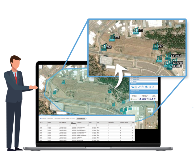
Locus Technologies has been a leader in bringing GeoBI to environmental data management. Locus’ software supports non-spatial data analysis via reporting, charting, and expert query functionality. The Locus GIS+ add-on lets you add spatial data to your analysis with the GIS+ functions for spatial query, data classification, time series analysis, buffering, and contouring. Let’s look at some examples.

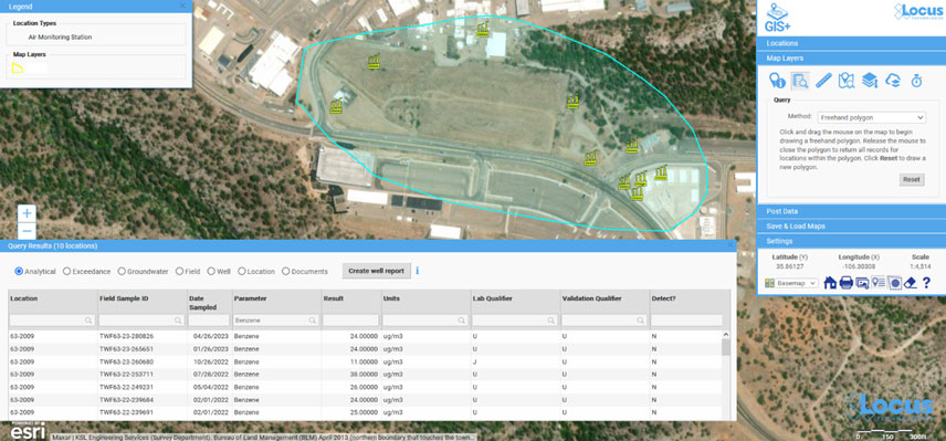
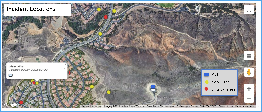
The above examples show how GeoBI can bring all your data together for use in analysis and decision-making, leading to a more complete picture of your facilities and processes. Furthermore, by having one suite of applications for your GeoBI needs, your organization can be more efficient. If spatial and non-spatial data are in separate silos, accessible only by different staff, it is difficult for one person to perform a complete analysis. Files, maps, spreadsheets, and other data objects must be shuffled between different persons and applications. With your data in Locus software, a full GeoBI analysis can be performed by one person, leading to productivity gains and cost reductions.
In the future, advances in artificial intelligence (AI) could lead to GeoAI, which would combine GeoBI with powerful features such as predictive analytics, pattern mining, and anomaly detection. Stay tuned for a future blog post on these exciting possibilities!
Acknowledgments: All the data used in the examples was obtained from the publicly available chemical datasets online at Intellus New Mexico.

I am constantly reminded by the number of calls we receive, that no matter how robust a SCADA and HMI system is, there is always a requirement for in-field O&M verifications and documentation. It’s almost universal and spans a myriad of industries, large and small, the need to monitor and record thousands of periodic (daily/per shift/weekly, etc.) routine readings/recordings at a prescribed frequency often recorded on pen to paper field forms. The same processes sometimes use “template” spreadsheets for data collection that are then emailed/placed on shared file servers or otherwise sent to some central location for review and post-processing. These processes are antiquated and subject to data quality and record-keeping challenges.
It’s time for an upgrade!
Electronic forms are great for collecting data and almost every business entity has built such forms in spreadsheets, word processing, or simple databases to collect the information. In addition, there is a software category of form builders, and they can certainly build forms. The question becomes is it a good fit to solve your business process issues?
Most customers have more sophisticated needs than simply collecting information on one or more custom forms – they want to do something with all the information collected far beyond what simple form builder tools can provide. Even customers with sophisticated spreadsheet forms, can’t manage them as they multiply exponentially or their Excel gurus retire.
Locus Platform is a configurable platform with standard applications that are easy to configure to customers’ unique requirements. One of its many strengths is its powerful form builder capable of creating simple or complex forms with simple or sophisticated logic. So, for customers looking to move from paper and spreadsheet templates, it’s an excellent option to consider, especially if you require more than a simple “fill in the blank” form for transmittal using mobile devices. Best of all, the data are securely stored in a database structure for reporting and alternative business uses and analyses, compared to the almost impossible management of hundreds of spreadsheets or paper forms.
If you still rely on paper forms and template spreadsheets and are ready to streamline your process and enhance the value of your data, give us a call and we can show you a range of options that will retire the paper forms for good!
[sc_vimeo width=”640″ height=”360″ aspect_ratio=”16:9″ video_id=”829536455″ style=”default” position=”right”]
Wading through the labyrinth of data to calculate your ESG can be a daunting task. To ease your burden, Locus Technologies has created the Locus Calculation Visualizer, making the process easy. In this short video Steve Paff, Director of Sales Engineering, shows how easy it is to gain actionable insights into your reported ESG data.
For more information, click the link below.
[sc_button link=”https://www.locustec.com/blog/getting-started-with-esg/” text=”Learn more” link_target=”_self” color=”000000″ background_color=”52a6ea”]
[sc_vimeo width=”640″ height=”360″ aspect_ratio=”16:9″ video_id=”827741964″ style=”default” position=”right”]
Data portability is something everyone uses and doesn’t think twice about. Without data portability, your data may be locked into separate silos that don’t communicate with each other. VP of Data Management and Visualization, Todd Pierce explains in this short video how Locus Technologies data portability can be available for all your data needs.
To see how a customized solution will work for your company, click the link below.
[sc_button link=”https://www.locustec.com/company/contact/” text=”Learn more” link_target=”_self” color=”000000″ background_color=”52a6ea”]
[sc_vimeo width=”640″ height=”360″ aspect_ratio=”16:9″ video_id=”827408894″ style=”default” position=”right”]
While we now have easy-to-use tools for creating applications, you still need to define what you want to get out of the application you’re making. When you buy pre-configured software, you adapt your process to fit the constraints of the system you just bought. When you buy configurable software, you’re able to create the exact workflow that you need, but you have to first develop a complete understanding of what your needs actually are.
With flexible tools, it’s easy to try out different configurations with your team members. In this short video Director of Sales Engineering, Steve Paff, highlights Locus Software’s configurable hierarchy and how versatile it can be for you.
For more information, click here:
[sc_button link=”https://www.locustec.com/blog/configurable-software-solutions-change-good-right/” text=”Learn more” link_target=”_self” color=”000000″ background_color=”52a6ea”]
Locus delivers capabilities that enterprises need to achieve true digital transformation in a unified low-code or no-code automation platform. Locus provides out-of-the-box tools and services to automate business processes, integrate with external applications, and provide a rich user experience.
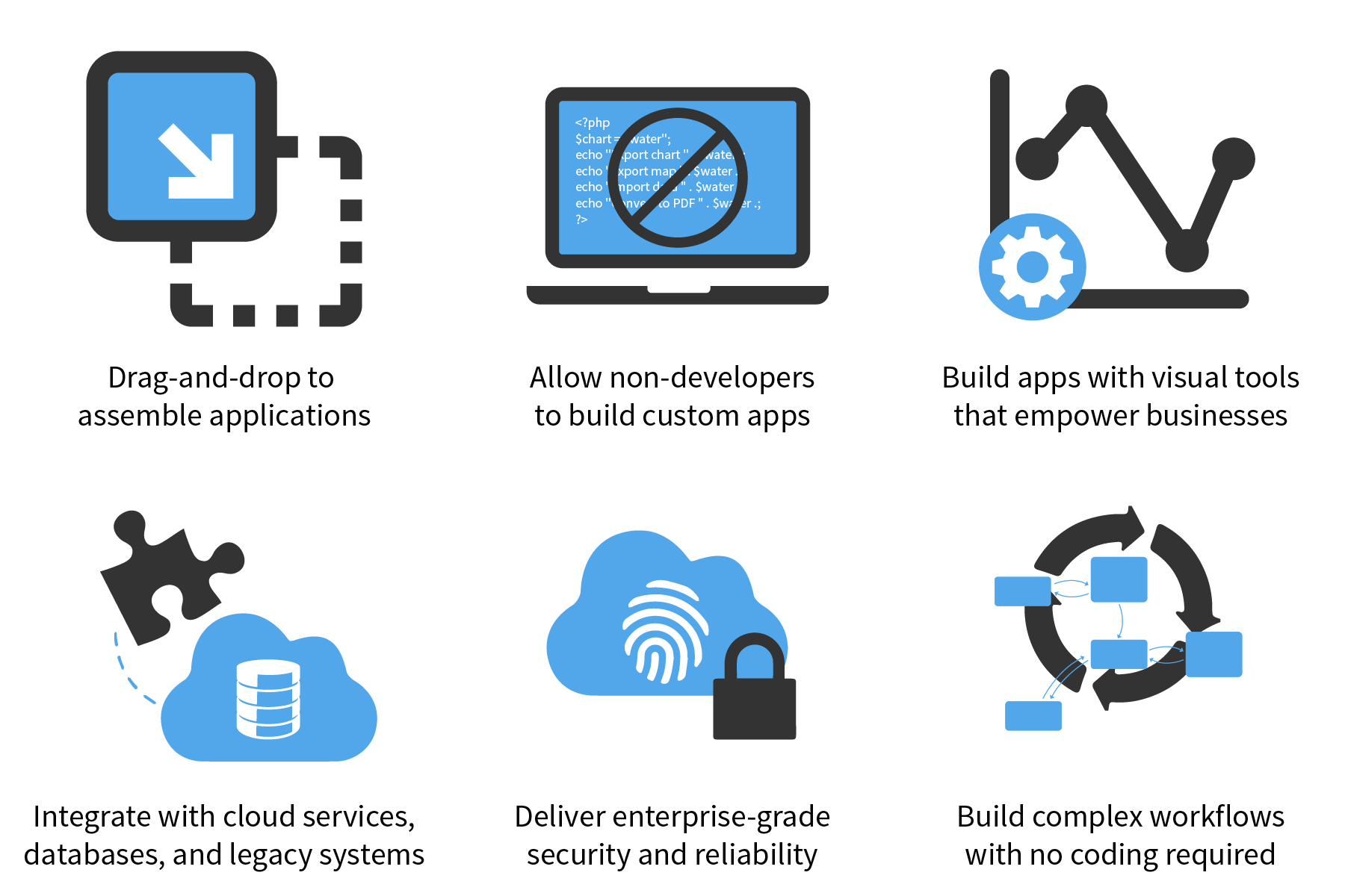
No-Code EHS Application Development
Locus offers low-code app building, rich multi-experience capabilities, business process orchestration, automated decision making, and easy integration with other databases. Locus makes it easy to modify existing seeded apps or build entirely new apps in a few clicks and provides easy ways to write business logic to solve challenging EHS or ESG problems. We let you blend “off the shelf” apps and unique requirements with exceptional ease.
If you know how to layout slides, if you can draw a flow chart, build a spreadsheet using formulae, sorting, with tables and charts, then you are a User Developer. We empower domain experts to build applications within the Locus Platform using the platform’s drag and drop functionality.
No-code development platforms provide drag-and-drop tools that enable end-users with proper access privileges to develop software quickly without coding. Locus Platform provides WYSIWYG editors and drag-and-drop components to rapidly assemble and design EHS, ESG, or any other application applications. Both developers and non-developers can use these tools to practice rapid application development with customized workflows and functionality. Locus Platform provides tools for enterprise-sized businesses that need to quickly design business processes and workflow applications at a large scale, such as ESG reporting or EHS compliance management. The software tools provide templates for workflow, element libraries, and interface customization to create fully functioning applications without any coding.
With Locus, your organization can:
[sc_button link=”https://www.locustec.com/applications/ehs-compliance/custom-apps/” text=”More on Custom Apps” link_target=”_self” centered=”1″]
The biggest differentiator between Locus and other EHS software providers is our support team. Not only do we pride ourselves on the quickest and most efficient resolutions in the industry, but on our human approach to support. Get to know our support team as we recently sat down (virtually) with them to talk about the ins and outs of their field, how it is working for Locus, and more.
Our most common support case is user management related. Many times, our customers need assistance adding new users or updating their user lists. We receive a lot of requests for resetting passwords.
Almost ten years ago, there was a bug within SQL itself! It was quite a mystery. We would venture to say that we have at least one unique case every week. No single case is the same! It certainly keeps us on our toes. We also had a case once where an organization was acquired by another organization. Due to this, we had to rename the users and organizations which ended up resulting in over 300 user changes which impacted historic records.
It is our policy to respond to all cases within two hours of receiving them (given that they come in between the hours of 5am and 3pm Pacific Time). If they come in outside of those hours, we respond within 2 hours of beginning our normal hours. We get many compliments on how speedy our response times are! It is the policy of the team for Tier 1 staff members to check new cases every thirty minutes or so. Critical issues typically receive almost immediate responses! Quick response times are one of our proudest achievements.
We have had many cases where we have received numerous thank yous from the customer. There has been a time or two when a customer did a widespread data update without meaning to. Our quick response and ability to revert their changes was much appreciated. We have also been known to help our customers with some very interesting issues that require quite a bit of troubleshooting on our end. The Support Team is incredibly patient and willing to dive deep into questions that customer’s come to us with.
The Locus Support Team consists of many individuals from a variety of backgrounds ranging from Environmental Engineering, Biology, Environmental Science, Environmental Health and Safety, Mathematics, Data Management, GIS, and much more! The Tier 1 team consists of three outstanding individuals who work across the Support Team, Engineering Team, and Configuration team. The Tier 2 team consists of a wide variety of developers, configurators, and specialists in the field. Together, the Locus Support team has over 75 years of combined experience in the Environmental field. We have a few folks on the team that have outward appearances outside of the norm ranging from long hair, piercings, tattoos, and even purple hair.
Because our team is spread across the United States, with team members working out of the Asheville and Mountain View offices, as well as remote employees, we haven’t been impacted as much by the stay at home COVID-19 orders. Our team has always excelled at communication through email and other online chat services. The ability to talk through tools such as Teams and Skype, has given us the advantage edge during this pandemic. In addition, a large number of our Support Team are remote employees ranging across California, Tennessee, Indiana, Utah, and many other states.
The first answer that came to the team was that we are all a family! We are incredibly supportive and encouraging of one another and we have FUN while working! One of the fun things that we all have in common is our deep–rooted love for animals. One of our favorite pastimes is sharing pictures of our animals, as well as their silly antics! We also like to share about our parenting concerns, particularly during COVID-19 times! Locus is an amazing place to work, in part because of the educated, experienced and awesome personalities we have working as a WHOLE team, rather than just a support team. When asked, the number one response was the friendly and family-like atmosphere.
Master of Applied Science
Associate’s
Bachelor of Science
Certifications
[sc_button link=”https://www.locustec.com/services/technical-support-training/” text=”More on Locus Support” link_target=”_self” centered=”1″]
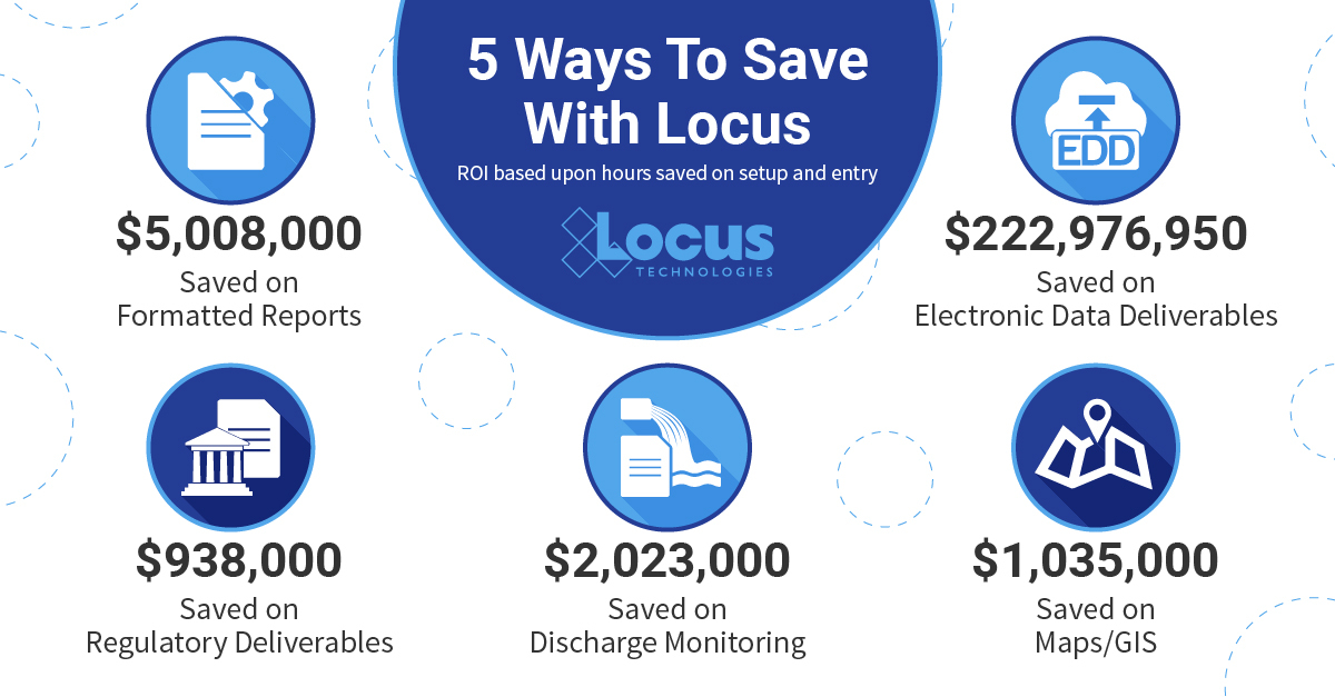
For over 20 years, Locus environmental software customers have saved enormously on their setup and and data entry costs. This infographic highlights the aggregate savings of all users based on conservative estimates of time and cost for different aspects related to our software.